Turkmenistan | Tagtabazar | Yekedeshik Cave Complex | Part 1
Wandered by the Yekedeshik Cave Complex located 290 miles as the crow flies southeast of Ashgabat. To get there from Ashgabat you have to drive 230 miles to Baramaly, the nearest town to the ruins of ancient Merv, and then drive south 120 miles to Tagtabazar, the nearest town to the caves. The actual driving distance is well over 300 miles. From Baramaly the road follows roughly the valley of the Murghab River, which begins on a plateau located between the Band-i Turkestan, Gharjistan, and Paropamisus mountains in what is now Afghanistan. From its source the Murghab flows north approximately 510 miles before disappearing into the sands of the Kara Kum Desert. As we shall have ample opportunities to see, the Murghab Valley vies with Egypt and Mesopotamia as the home of one of the world’s oldest civilizations.
South of Barmamaly a new highway is under construction and the temporary dirt roads are clogged with trucks, tankers, and buses bound for the natural gas processing plants which lie off in the desert to the right. Companies from Russia, India, Turkey, China, Japan, Malaysia, and Saudi Arabia have all built plants here. It is the natural gas processed in these and other plants that have paid for the Expanses of White Marble in Ashgabat. After about fifty miles we past through the industrial zone and traffic thins out considerably. Although the Murghab Valley south of Baramaly is flanked on both sides by desert, the valley bottom itself is quite fertile. This land has been cultivated for at the very least the last 4000 years. In early May extensive fields of winter wheat lining the road are just starting to take on a hint of yellow. Numerous towns and villages lie along the river to the left.
We pass through one of the ubiquitous police posts where my papers are checked and then just before Tagtabazar are stopped at a border zone checkpoint where my permit to travel in a restricted border area is perused. The Afghan border is, after all, just fourteen miles away. Although the Yekedeshik Caves are not quite on the well-trodden tourism path in Turkmenistan a trickle of visitors from other countries do come here and the border authorities are used to dealing with them. It takes the officials only twenty minutes to determine that my papers are in order.
There appears to be little of interest in the small town of Tagtabazar itself. We cross the bridge over the Murghab and turn off on the dirt road which climbs the high bluffs to the east of the river. The river bottom is at an elevation of roughly 1120 feet. The entrance to the caves is in the side of the bluffs about 350 vertical feet about the river bottom.
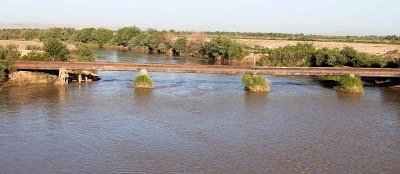
The Murghab River fourteen miles downstream from the Afghanistan border (click on photos for enlargements)
The entrance to the Yekedeshik Cave Complex, roughly 350 vertical feet above the valley bottom of the Murghab River, can just be seen near the center of this photo.
The entrance to the Yekedeshik Cave Complex with the valley of the Murghab River stretching off to the south.
The valley of the Murghab River. Although flanked by desert, the valley bottom itself is heavily cultivated.
Entrance to the Yekedeshik Cave Complex


