Uzbekistan | Caravanserais | Vabkent Minaret | Tavois | Rabat-i-Malik
Before indulging in further Ambulations of Bukhara City itself I decided to wander north through the Bukhara conurbation and look for other monuments which pre-dated the Mongol invasion and managed to survive down to the present day. My first stop was Vabkent, seventeen miles north-northeast of Bukhara. When first Chingis Khan and his army approached the Bukhara Oasis they may well have homed in on Vabkent’s minaret, which was visible for miles around and served as a beacon for caravans and travelers approaching from the north. Commissioned by Abd al-Aziz II, a member of a powerful Bukhara family during the time of the Qara Khitai Khanate (c. 1125–1218), the 127-foot high minaret, completed in 1198–1199, was the second highest in Mawarannahr, after the Kalon Minaret in Bukhara itself. The Qara Khitai, as you probably know, were a remnant of the old Khitan Dynasty in China—they also Controlled Most of Mongolia At The Time)—who had migrated west and established an empire in Inner Asia. They were Buddhists, with perhaps a smattering of Nestorian Christians among them, but they left the local people to whom they were suzerains practice their own religions, hence this imposing minaret and accompanying mosque in Vabkent. The Mongols left it unharmed, although the mosque it was once attached to has long since disappeared.
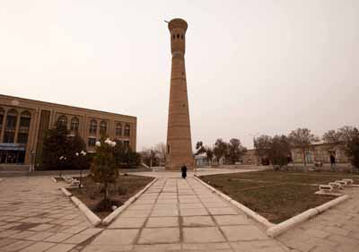
Vabkent Minaret

Vabkent Minaret

Vabkent Minaret

Vabkent Minaret

Vabkent Minaret
Sixteen miles east of Vabkent is Tavois. In the thirteenth century it was large town or even city, but now it is a mere village overshadowed by the nearby modern town of Kizil Tepe. Up until the eighth century the town was known as Arqud. Arab invaders renamed it Tawais (“Endowed with Peacocks”) in 710 because it was here they saw their first peacocks—not a native bird of Arabia—in the gardens of the town’s prominent citizens. The town had a large Friday mosque, but by the time Chingis arrived the local fortress had fallen to ruins, already destroyed in earlier fighting between the various contestants for the Bukhara conurbation. The town was formerly famous of its Zoroastrian temple, although presumably it too had disappeared by the thirteenth century, by which time Islam had long since dominated the area.
Every autumn Tawais hosted a great trade fair which lasted seven to ten days. Merchants from all of Mawarannahr and the Fergana Valley attended this fair, which operated under one unusual condition: no item bought could be returned, even if it was later proven that the seller had engaged in illegal trickery and deception. Although probably in a hurry to get to Bukhara, presumably the Mongols took time to engage in at least a cursory looting of the town and to dragoon levies for the anticipated lengthy siege of Bukhara. Now, as in the thirteenth century, it marks the place where the cultivated land of the Bukhara Oasis abruptly ends and the desert steppe begins.

Tavois, the current name of the village, is a corruption of the original Arab word Tawais.
Tawais was located just inside the great wall known as “Kanpirak”. This wall, measuring some 150 miles in length, had once surrounded the entire Bukhara Oasis. Kanpirak is supposedly an archaic term for “Old Woman”, which would at first glance seem an inappropriate term for a wall. One local historian points out, however, that “old virgin” might be a more accurate translation, in which case the term might connote that the wall was thought to be impenetrable. In any case, the wall was probably built in the fifth or sixth century a.d. Between the years 782 and 830 it was repaired and upgraded as a bulwark against the continuing incursions of nomadic peoples from the north. Maintaining the lengthy wall was an immensely expensive undertaking, however, and required enormous outlays of man-power. At the beginning of the Samanid era in the ninth century Amir Ismael famously declared, “While I live, I am the wall of the district of Bukhara,” implying that he would guarantee the safely of the area by force of arms and that expensive walls were no longer needed. The Kanpirak was henceforth abandoned, and by the time the Mongols arrived it may have been in ruins. In any case, neither Juvaini nor any other Persian historians of the thirteenth century even mention the wall and it proved no obstacle whatsoever to the Mongol invaders. Some commentators insist that ruins of the wall can still be seen at places, but local historians could not point me to any remnants and I was unable to find any traces of it. I apologize for this failure and will attempt a more diligent search during my next trip to Uzbekistan.
Tavois also marks the beginning of the so-called Royal Road to Samarkand, further on east. An ancient trunk of the Silk Road connecting the two pearls of Mawarannahr, Bukhara and Samarkand, the route still serves as the main highway between the two cites. Eighteen miles east-northeast of Tavois are the ruins of Rabat-i-Malik, a immense caravanserai built by the Qarakhanid Khan Shams-al-Mulk Nasr (r. 1068–1080) for the use of merchants and travelers on the Royal Road. Nearby was a huge well of sweet water which would have slaked the thirst of the men and their horses (the huge brick dome which now covered the well was not added until the 14th century).

The well, with 14th century brick dome

Entrance to the well

Entrance to the well

The huge portal of the Malik Caravanserai

Another view of the portal

Detail of brick work on the portal (see Enlargment)

Interior of the caravanseria, showing layout of the rooms. The entire complex measuring about 300 feet by 300 feet.

These now-truncated columns may have belonged to a mosque in the middle of the caravanseria.

View of the portal from inside the caravanserai.

Ruins within the caravanserai

Ruins of what may have been ovens